Whether you are plotting cross-country road trips, marking off states you have visited, or simply want a reliable geographic reference for a home office or classroom, the ideal America wall map needs to balance legible detail with a size that fits your available wall space. Too small and you lose the nuance of mountain ranges and county-level road networks; too large and the map overwhelms the room or becomes difficult to read at close range.
I’m Min — the co-founder and writer behind Gadgets Feed. My approach to this guide involved cross-referencing customer reports on print clarity, lamination durability, and dimensional accuracy across multiple cartographic brands to find the maps that actually deliver on their claims.
After comparing print quality, surface finish, and real-world usability for marking travel routes, I have narrowed the field to the most dependable options. Read on for my curated selection of the best america wall map for every use case.
How To Choose The Best America Wall Map
An America wall map is a long-term fixture, so the wrong choice means squinting at tiny labels or dealing with a flimsy sheet that curls at the edges. Focus on material, size, and the specific marking system you intend to use.
Lamination Type and Surface Durability
A map that you plan to write on or stick pushpins into needs a robust surface. Matte lamination reduces glare but can show scuffs from dry-erase markers; glossy lamination offers better erasability but reflects overhead light. For scratch-off maps, the gold foil layer must adhere evenly so it does not chip when you rub off a state.
Scale, Detail Density, and Readability
A 24 x 36 inch map fits standard poster frames but compresses town-level detail in densely populated regions like the Northeast. At 32 x 50 inches or larger, highways and small cities become clearly legible without a magnifying glass. The ideal size depends on the distance from which you will view the map — measure your wall and your typical reading distance before deciding.
Print Accuracy and Cartographic Style
National Geographic and Rand McNally use hand-drawn shaded relief and verified road networks, which matters if you rely on the map for route planning. Cheaper maps often copy outdated base data and miss recent highway changes or new park boundaries. The style — from antique earth tones to vibrant solid-state fills — also affects how easily you can distinguish neighboring states at a glance.
Quick Comparison
On smaller screens, swipe sideways to see the full table.
| Model | Category | Best For | Key Spec | Amazon |
|---|---|---|---|---|
| National Geographic United States Wall Map – Classic | Premium Reference | Detailed cartographic reference with hand-drawn relief | 43.5 x 30.5 in, matte poster stock | Amazon |
| Rand McNally Classic Edition U.S. Wall Map | Premium Laminated | Sleek executive-style décor with topographical shading | 50 x 32 in, gloss lamination | Amazon |
| Swiftmaps 24×36 United States Classic Premier | Mid-Range Dry-Erase | Budget-friendly dry-erase map at standard frame size | 24 x 36 in, 2-sided lamination | Amazon |
| Swiftmaps 32×50 United States Classic Premier | Mid-Range Large Format | Oversized map with vivid 3D terrain relief | 32 x 50 in, glossy lamination | Amazon |
| Travelization Scratch Off Map of United States | Premium Interactive | Travel tracking with scratch-off foil and National Park markers | 24 x 17 in, scratchable foil layer | Amazon |
| House of Doolittle Write On/Wipe Off Laminated US Map | Mid-Range Educational | Classroom and office use with reusable dry-erase surface | 50 x 33 in, heavy laminated write-on surface | Amazon |
| Maps International Classic USA Wall Map | Mid-Range Front-Laminated | Sleek décor piece with write-on front lamination | 24 x 36 in, front sheet lamination | Amazon |
In‑Depth Reviews
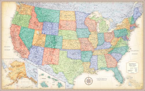
1. National Geographic United States Wall Map – Classic (43.5 x 30.5 in)

National Geographic’s Classic style stands out for its hand-drawn shaded relief and bathymetric contour steps in the blue ocean areas. The 43.5 x 30.5 inch format gives you a large canvas without requiring an oversized custom frame — it fits most standard 30-inch-wide spaces. The Lambert Conformal Conic projection minimizes east-west distortion across the continental US, so the shapes of the states look correct along the entire width of the map.
Customers consistently report that the matte poster stock takes pushpins well and holds Sharpie ink without bleeding. The 2021 edition data includes updated National Park boundaries and road networks, which matters if you use the map to plan visits to specific federal lands. The color-coded state borders and detailed inset maps of Alaska, Hawaii, and Puerto Rico give you complete coverage without sacrificing the main view.
One trade-off: the white border around the printed area is roughly two inches wide, which reduces the usable map surface slightly. Buyers who want every inch of wall space filled with geography sometimes trim the border before framing. Still, the level of cartographic research and the nonprofit backing of the National Geographic Society make this the most trustworthy reference map on this list.
Why it’s great
- Hand-drawn shaded relief provides a realistic 3D look of mountain ranges
- Matte poster stock works well with pushpins and markers for route tracking
Good to know
- 2-inch white border reduces the printable map area
- Small-town labels can be hard to read without magnification
2. Rand McNally Classic Edition U.S. Wall Map – Laminated Rolled
The Rand McNally Classic Edition uses a parchment-toned background with antique-style accents that give it an executive look suitable for an office or a study. At 50 x 32 inches, it is one of the largest rolled laminated maps available, which means state boundaries, interstates, and topographical features are large enough to read from across a room. The gloss lamination protects the surface from smudges and makes it easy to wipe clean if you use dry-erase markers.
Color-matched relief shading helps you spot mountain ranges and elevations at a glance without needing separate contour lines. The map covers the entire contiguous United States and includes insets for Alaska and Hawaii. Reviewers frequently mention that the rolled tube packaging protects the map during delivery, and the gloss finish resists curling even in humid environments.
The lamination layer is on the thinner side compared to industrial-grade classroom maps, so it may not hold up to heavy repeated erasing or aggressive marker use over many years. If you plan to use the map primarily as a decorative reference rather than a daily writing board, this issue is negligible.
Why it’s great
- Large 50 x 32 inch format offers excellent legibility of highways and cities
- Gloss lamination wipes clean easily and resists moisture
Good to know
- Lamination is relatively thin and may tear with rough handling
- Antique color palette may not suit bright, modern room decor
3. Swiftmaps 24×36 United States Classic Premier Blue Oceans 3D Wall Map Poster (Laminated)

The Swiftmaps Classic Premier map hits a sweet spot between cost and functionality. The 24 x 36 inch size matches standard poster frames exactly, so you do not need custom framing. The printed 24lb poster paper is reinforced with a durable 2-sided lamination that accepts dry-erase markers, which makes this map ideal for tracking delivery territories or marking sales regions.
The 3D relief effect uses color shading rather than true raised topography, but the visual depth is convincing enough at reading distance. City labeling is dense — major cities are bold and easy to locate, while smaller towns appear in readable sans-serif type. The political boundaries are updated, so you get current state and county lines without outdated references.
Some buyers note that the lamination can develop slight bubbles near the edges if the map is stored in a hot environment before hanging. The blue ocean color is vivid but can appear oversaturated under direct sunlight. For the price, however, this is a competent map that handles daily marker use without ghosting.
Why it’s great
- Fits standard 24 x 36 inch frames without any trimming
- Dry-erase lamination wipes clean with no residue or ghosting
Good to know
- Lamination may develop small bubbles in high heat
- Blue ocean color can look oversaturated in bright rooms
4. Swiftmaps 32×50 United States Classic Premier Blue Oceans 3D Wall Map Poster (Laminated)
If you have the wall space, the 32 x 50 inch variant of the Swiftmaps Premier map delivers the same vivid color mapping and 3D relief shading as its smaller sibling but at a scale that makes even rural county roads readable without squinting. The larger footprint is especially useful for route planners who need to see the entire continental US layout at a single glance.
The 2-sided glossy lamination is identical to the 24 x 36 version, so you can write directly on the surface with dry-erase markers and wipe it clean. The political data is updated yearly, which keeps state boundaries and major highway numbers current. Buyers who use it for sales territory mapping report that the color differentiation between states is strong enough to avoid confusion even when the map is crowded with marker annotations.
The main drawback is the sheer size — this map cannot fit into a standard frame without custom framing or mounting with adhesive strips. The rolled tube delivery means it arrives flat, but you need careful handling during installation because the glossy surface shows fingerprints easily.
Why it’s great
- Massive 32 x 50 inch size makes even small towns and backroads legible
- Glossy dry-erase surface is easy to clean for repeated use
Good to know
- No standard frame fits this size — requires custom framing or adhesive mounting
- Glossy surface attracts fingerprints during handling
5. Travelization Scratch Off Map of United States 24 x 17 in

The Travelization Scratch Off Map transforms your wall into a travel log. Its gold foil coating covers the entire continental United States, and as you scratch off states you have visited, a vibrant multicolor map emerges underneath. The 24 x 17 inch size is intentionally compact so it fits easily into a standard 24 x 18 inch frame, making it a popular choice for living rooms and entryways.
The map includes icons for all 61 National Parks (each marked in green), state flags printed along the border, and the highest peak in every state. A steel scratching tool is included, and the foil removes cleanly without leaving sticky residue. Customers report that the scratch-off process is satisfying and the underlying print is detailed enough to show highways, rivers, and terrain shading.
The foil can be difficult to scratch off in small states like Rhode Island and Delaware because the surface area is tiny — you need a precision tool or a fingernail to start the edge. Also, this is strictly a decorative tracking map; it does not have a laminated surface, so you cannot write on it with dry-erase markers.
Why it’s great
- Interactive scratch-off design makes travel tracking fun and visual
- Includes National Park locations, state flags, and highest peaks
Good to know
- Small eastern states are tricky to scratch off cleanly
- Not a write-on surface — decorative tracking only
6. House of Doolittle Write On/Wipe Off Laminated United States Map 50 x 33 in (HOD720)
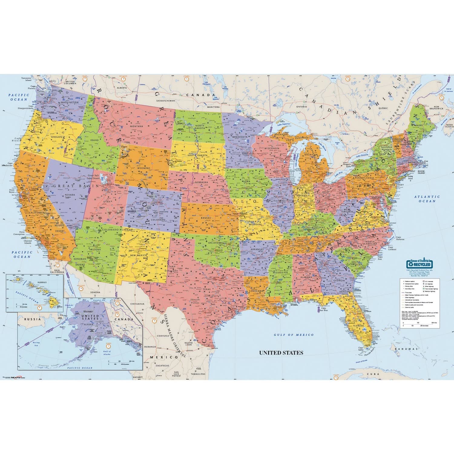
House of Doolittle builds this map using 100% recycled paper stock and prints with soy-based inks, which gives it a slightly muted color palette compared to the bold synthetic prints from Swiftmaps or Rand McNally. The heavy lamination is thick enough to withstand daily erasing in a school or office setting, and the write-on/wipe-off surface works with any water-soluble marker.
At 50 x 33 inches, the map covers the contiguous 48 states plus Alaska and Hawaii in clear detail. The included water-soluble marker is a nice bonus, and the four peel-and-stick tabs make hanging a one-person job. The map includes time zone boundaries, major peak elevations, and river systems, which makes it a complete educational resource for geography students.
The eco-friendly ink is less vibrant than synthetic prints — buyers expecting bright neon colors may find the palette subdued. Additionally, the lamination can produce a slight glare under fluorescent classroom lights. Dry-erase markers from other brands leave faint residue that requires a quick damp wipe to fully remove.
Why it’s great
- Thick laminated surface holds up to daily classroom and office erasing
- Made from 100% recycled paper with eco-friendly soy inks
Good to know
- Print colors are muted compared to synthetic maps
- Lamination glare can be an issue under bright fluorescent lights
7. Maps International Classic USA Wall Map – Front Lamination – 24 x 36 in

Maps International uses a classic color palette with muted earth tones and a subtle beige background that blends well with wood furniture and neutral wall colors. The 24 x 36 inch poster size is standard, so you can frame it easily. The front lamination provides a write-on surface, but only on the printed side — the back is uncoated paper.
The cartography includes clear state and city labeling, major highways with route numbers, and shaded relief for mountain ranges. The map ships in a sturdy tube and arrives flat without creases. Customers praise the color balance and the clean, uncluttered look that works as a permanent wall decoration rather than just a utilitarian map.
The front-only lamination is a trade-off: the map is less durable than a fully laminated product, and if you need to erase marker ink repeatedly, the paper backing may curl over time. Additionally, the absence of back lamination means the map is more susceptible to moisture damage if hung in a basement or humid room.
Why it’s great
- Elegant earth-tone color scheme fits home and office decor
- Standard 24 x 36 inch size fits off-the-shelf frames
Good to know
- Front-only lamination makes the map less durable for heavy marker use
- Uncoated paper back can curl when exposed to humidity
FAQ
What is the best size for an America wall map at home?
Can I use dry-erase markers on a laminated wall map?
How do I hang a rolled map without damaging it?
Final Thoughts: The Verdict
For most users, the best america wall map winner is the National Geographic United States Wall Map – Classic because its hand-drawn shaded relief and verified road data make it both a beautiful decorative piece and a reliable reference tool. If you want an interactive travel tracker, grab the Travelization Scratch Off Map and start scratching off the states you have explored. And for repeated dry-erase use in a classroom or office, nothing beats the House of Doolittle Write On/Wipe Off Laminated Map with its eco-friendly build and thick laminated surface.