A dead phone battery on a ridge at dusk is a hard way to learn that a phone app is not a real navigation tool. Dedicated handheld backpacking GPS units use multi-band GNSS chips and preloaded topo maps to give you position data that works for days, not hours, regardless of whether trees or canyons block the sky.
I’m Min — the co-founder and writer behind Gadgets Feed. I spend my time cross-referencing satellite receiver specifications, battery run-time tests, and map-loading workflows to separate the units that belong on a real trip from the ones that belong in a drawer.
This guide compares eight handhelds that can handle actual backcountry navigation, from budget-friendly options to premium satellite communicators, to help you find the best backpacking gps for your terrain and trip duration.
How To Choose The Best Backpacking GPS
A handheld GPS for backpacking is not the same as a car navigator or a phone app. The key differences come down to how well the device holds a signal under tree cover, how long it runs on a single set of batteries, and whether the preloaded maps include the trails and elevation data you actually need. Prioritize satellite receiver quality over screen size, and battery flexibility over glossy features.
Multi-Band GNSS vs. Standard GPS
A standard GPS receiver works fine in open fields, but performance degrades fast under dense forest canopy or inside narrow canyons. Multi-band GNSS receivers — found on the Garmin GPSMAP 65s and GPSMAP 67i — pull signals from GPS, GLONASS, Galileo, and QZSS simultaneously. This gives you a position lock within roughly 6 feet even when the sky view is obstructed. If your backpacking route involves thick timber or steep valleys, a multi-band unit is worth the step up in price.
Battery Life and Power Flexibility
Battery life ratings in GPS mode tell you how long the unit will run with full satellite tracking active. The Garmin Montana 710 claims 24 hours, while the budget NiesahYan claims 36 hours — but real-world numbers depend on backlight brightness and how often you zoom. More important is whether the unit accepts standard AA batteries. Units that rely only on internal lithium-ion packs (like the Montana 700 and inReach Explorer+) need a power bank for extended trips, while AA-compatible models let you carry spares from any convenience store.
Preloaded Maps vs. Map Loading Workflow
Every unit in this guide ships with some form of topo map, but the map quality varies. Garmin’s TopoActive maps include routable trails and public land boundaries, while the NiesahYan uses a generic USA topo base. The real pain point is the workflow to load custom maps: Garmin’s BaseCamp software is powerful but has a steep learning curve. If you plan to use free OpenStreetMap data or paid 24K topo maps, make sure the unit supports microSD expansion — the Garmin GPSMAP 64sx and Montana 760i do, the inReach Explorer+ does not.
Quick Comparison
On smaller screens, swipe sideways to see the full table.
| Model | Category | Best For | Key Spec | Amazon |
|---|---|---|---|---|
| Garmin GPSMAP 65s | Mid-Range | Multi-band accuracy | Multi-band GNSS + 16 hr battery | Amazon |
| Garmin Montana 700 | Premium | Large glove-friendly touchscreen | 5″ display + 18 hr battery | Amazon |
| Garmin Montana 710 | Premium | Satellite imagery + USB-C | 5″ screen + 32 GB + 24 hr battery | Amazon |
| Garmin Montana 760i | Premium | Built-in inReach + 8MP camera | inReach SOS + 24 hr battery + 32 GB | Amazon |
| Garmin GPSMAP 67i | Premium | Maximum battery + inReach | 425 hr expedition mode + multi-band | Amazon |
| Garmin inReach Explorer+ | Premium | Global satellite messaging | Iridium two-way text + 30 hr battery | Amazon |
| Garmin GPSMAP 64sx | Mid-Range | Reliable button operation | Quad helix antenna + 16 hr battery | Amazon |
| NiesahYan Handheld GPS | Budget | Long battery at low cost | 36 hr battery + 32 GB + IP66 | Amazon |
In‑Depth Reviews
1. Garmin GPSMAP 65s

The GPSMAP 65s delivers multi-band GNSS support — GPS, GLONASS, Galileo, and QZSS — that locks position within 6 feet even under dense tree cover or in steep terrain where standard receivers drift. The 2.6-inch sunlight-readable display with button operation means you can navigate in rain, snow, or with gloves on without smudging a touchscreen.
Battery life runs up to 16 hours in GPS mode on standard AA batteries, and real-world testing shows you can push that past 27 hours by enabling Battery Save mode and reducing backlight. The 3-axis compass and barometric altimeter give you accurate bearing and elevation data without needing to move, which matters when you are stopped at a junction checking the map.
The built-in TopoActive maps include routable trails and federal public land boundaries, and the device supports microSD expansion for custom 24K topo or OpenStreetMap data. The main weak point is Garmin’s BaseCamp software — expect to spend 4 to 6 hours learning the workflow for loading free maps.
Why it’s great
- Multi-band GNSS for accurate locks in difficult terrain
- Standard AA batteries, replaceable in the field
- Physical buttons work perfectly with gloves
Good to know
- BaseCamp software has a steep learning curve
- Default map detail is set to low out of the box
- 16-hour battery is average for its class
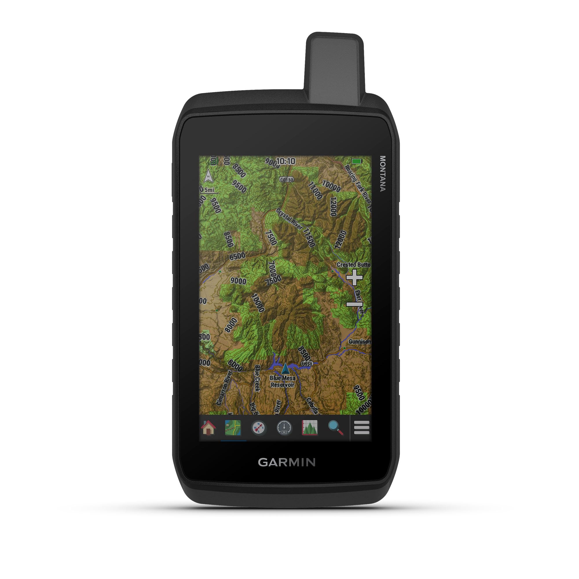
2. Garmin Montana 700

The Montana 700 features a 5-inch glove-friendly transflective touchscreen that is 50 percent larger than the previous generation, making it the easiest handheld to read for route planning and on-the-fly map scrolling. The rugged construction meets MIL-STD 810 standards for thermal, shock, and vibration, plus IPX7 water resistance — it survives drops, rain, and dust without issue.
Multi-GNSS support covers GPS, GLONASS, and Galileo, and the built-in ABC sensors (altimeter, barometer, compass) provide real-time elevation and weather data. Battery life is rated at 18 hours in GPS mode, and the lithium-ion battery pack is rechargeable. An optional AA battery adapter gives you backup power flexibility on longer trips.
The unit includes Wi-Fi, Bluetooth, and ANT+ connectivity for direct BirdsEye satellite imagery downloads, location sharing, and Connect IQ app support. Owners report that the preloaded TopoActive maps lack the contour detail needed for serious hunting, so plan to load additional 24K maps via microSD if you need fine terrain features.
Why it’s great
- Large 5-inch display is easy to read while moving
- MIL-STD 810 ruggedness for extreme conditions
- AA battery adapter available as backup
Good to know
- Preloaded topo maps lack fine contour lines
- No inReach satellite messaging built in
- Touchscreen can be less responsive when wet
3. Garmin GPSMAP 64sx

The GPSMAP 64sx uses a quad helix antenna paired with multi-GNSS support (GPS, GLONASS, Galileo) to maintain signal lock in environments where flat patch antennas struggle, such as slot canyons or thick pine forests. The 2.6-inch sunlight-readable color display and dedicated button interface keep navigation simple even in heavy rain or when you are wearing thick gloves.
Preloaded TopoActive maps cover the US and Australia with routable roads and trails, and the device supports microSD expansion for additional map data. The 3-axis compass and barometric altimeter give you accurate heading and elevation without relying on movement. Battery life runs 16 hours in GPS mode with standard AA batteries, and using lithium cells pushes that closer to 20 hours.
Wireless connectivity via Bluetooth and ANT+ enables smart notifications and data sharing with compatible devices. The lack of internal map storage — only 1.7 GB usable — means you will almost certainly need a microSD card for any serious map library. The BaseCamp software setup is the same learning curve as other Garmin units.
Why it’s great
- Quad helix antenna provides superior signal reception
- Button operation works reliably in all weather
- AA batteries are easy to replace on the trail
Good to know
- Limited internal memory requires a microSD card
- No multi-band GNSS for extreme accuracy
- 16-hour battery is average for the category
4. Garmin Montana 710
The Montana 710 brings a 5-inch glove-friendly touchscreen, 32 GB of internal memory, and USB-C charging to the handheld GPS category — a clear upgrade over earlier Montana models. The unit is MIL-STD 810 rated for thermal, shock, and vibration, plus IPX7 water resistance, so it withstands the abuse of ATV, dirt bike, or off-trail backpacking use.
Battery life reaches 24 hours in GPS mode and an exceptional 432 hours in expedition mode, which disables the display between waypoint captures to preserve power. The rechargeable lithium-ion battery pack is included, and the unit can also run on AA batteries with the optional adapter. Multi-GNSS support with ABC sensors gives you accurate position, elevation, and weather data.
The ability to download high-resolution satellite imagery via Wi-Fi and store it on the 32 GB internal memory or microSD card makes the 710 a powerful planning tool. Owners report that the touchscreen is faster and more precise than button-based Garmin units, though the software quirks with map management via BaseCamp persist. Some units have been reported with boot loop issues, so test the device before a major trip.
Why it’s great
- 32 GB internal memory plus microSD expansion
- USB-C charging is modern and convenient
- 432-hour expedition mode for multi-week trips
Good to know
- Some units have experienced boot loop failures
- Touchscreen less reliable in heavy rain
- Map loading workflow still requires BaseCamp
5. Garmin GPSMAP 67i
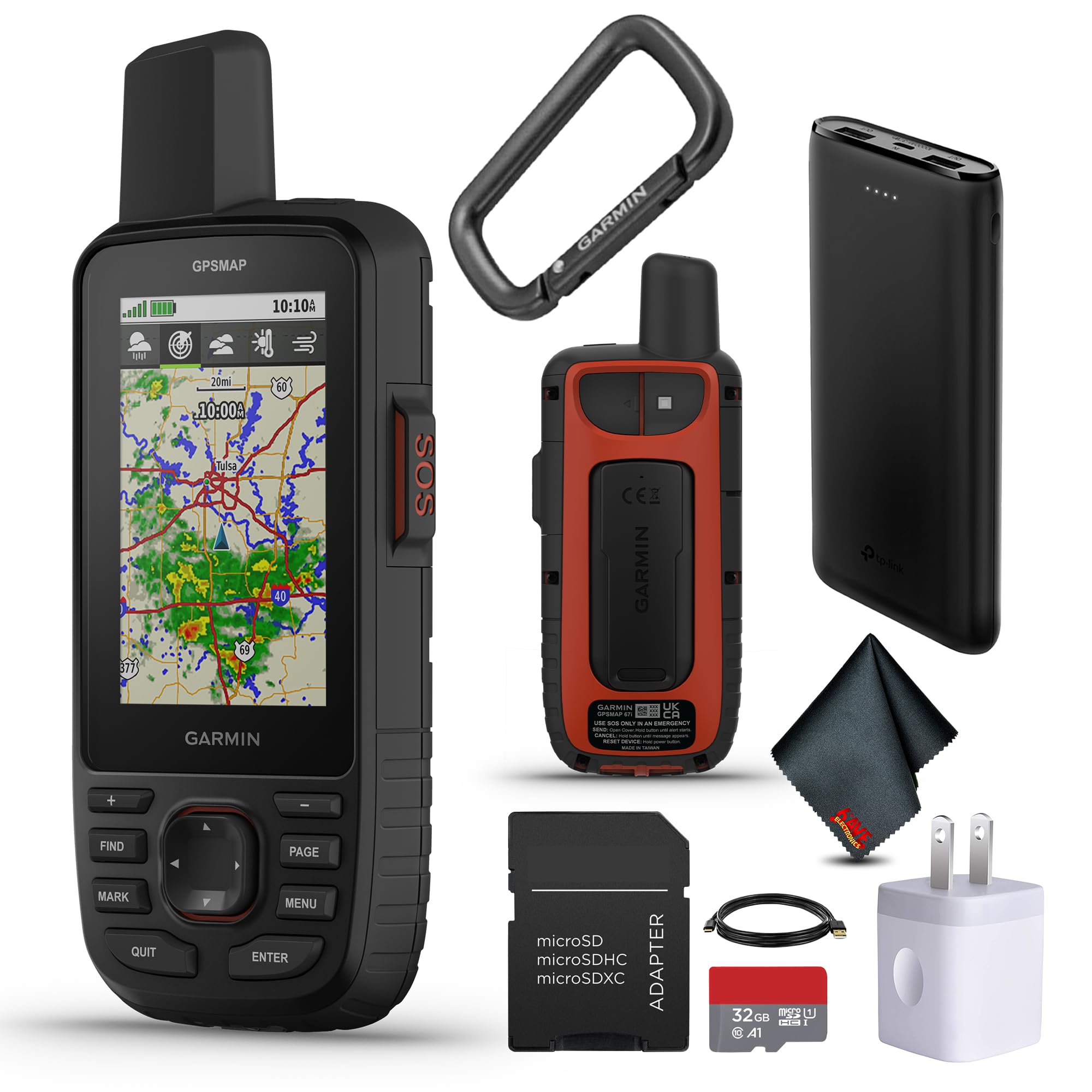
The GPSMAP 67i combines premium navigation with inReach satellite communication, giving you two-way messaging and interactive SOS via the Iridium satellite network. This bundle includes a 32 GB microSD card, a power bank, and charging adapters, so you are ready to go out of the box. The 3-inch sunlight-readable color display is smaller than the Montana series but still legible in direct sun.
The headline spec is 425 hours of battery life in expedition mode, which lets the device track your position every 10 minutes while keeping the screen off. In GPS mode with full tracking, you still get multi-band GNSS support for accurate locks under tree cover. Wi-Fi connectivity enables direct map downloads without needing a computer.
An active inReach subscription is required for two-way messaging and SOS, but the peace of mind is unmatched for solo backpackers and remote trips. The device also pairs with the Garmin Explore app for trip planning and data review. The unit is heavy at 1.5 pounds compared to the GPSMAP 65s, but the satellite capability and battery endurance justify the weight for serious expeditions.
Why it’s great
- 425-hour expedition mode for long trips
- Built-in inReach satellite SOS and messaging
- Multi-band GNSS for accurate positioning
Good to know
- Requires active subscription for satellite features
- Heavier than standard handheld GPS units
- Smaller screen than Montana series
6. Garmin inReach Explorer+

The inReach Explorer+ is built around Iridium satellite technology for 100 percent global two-way text messaging and SOS, making it the go-to device for backcountry communication beyond cell coverage. The preloaded DeLorme topo maps with on-screen GPS routing let you navigate without needing a phone, and the digital compass, barometric altimeter, and accelerometer provide essential orientation data.
Battery life is rated at 30 hours in tracking mode at 10-minute intervals, and real-world users report the device still has 60 percent charge after three days of moderate use. The Earthmate app pairs with your smartphone to enable keyboard-based texting and access to downloadable US NOAA charts and color aerial imagery, but the onboard maps are sufficient for standalone navigation.
The major drawback is that route planning on the device produces straight point-to-point lines rather than trail-snapping routes, so plan your routes in the Earthmate app beforehand. Subscription costs start around per month for the Safety Freedom plan.
Why it’s great
- Global Iridium satellite communication coverage
- 30-hour battery with moderate use
- Preloaded topo maps for standalone navigation
Good to know
- Requires ongoing satellite subscription
- Route planning creates straight lines, not trail-snapping
- No microSD expansion for additional maps
7. Garmin Montana 760i

The Montana 760i combines the 5-inch glove-friendly touchscreen of the Montana 700 with built-in inReach satellite technology for two-way messaging and SOS. It also includes an 8-megapixel autofocus camera that geotags photos, letting you navigate back to specific sites like a campsite or water source by following the photo location on the map.
Battery life matches the Montana 710 at 24 hours in GPS mode and 432 hours in expedition mode. The unit is MIL-STD 810 rated and IPX7 water-resistant, with 32 GB of internal memory plus a microSD slot for map expansion. Wi-Fi connectivity enables direct map and satellite imagery downloads, and the Garmin Explore app integration helps manage waypoints and trip data.
An active inReach subscription is required for the satellite features, but having SOS and messaging built into the same device that handles navigation eliminates the need to carry a separate communicator. Some units have been reported with boot loop failures, so thorough testing before a trip is essential. The street maps on some units have also caused frustration, requiring customer service calls to resolve.
Why it’s great
- GPS, camera, and satellite SOS in one device
- Geotagged photos for navigational waypoints
- 432-hour expedition mode for long trips
Good to know
- Requires inReach subscription for SOS and messaging
- Some units experience boot loop issues
- Street maps may need customer service to activate
8. NiesahYan Handheld GPS

The NiesahYan handheld GPS offers a 3.2-inch sunlight-readable LCD display with both touch and physical button input, plus a 36-hour battery life that exceeds most Garmin units. It preloads USA Topo maps and provides 32 GB of internal memory for additional map downloads, making it a capable entry-level option for day hikes and weekend trips on established trails.
Multi-GNSS support covers GPS, Galileo, BeiDou, and QZSS for position accuracy within 6 feet, and the 3-axis compass and barometric altimeter provide basic navigation data. The IP66 water resistance rating means it can handle rain and splashes but not submersion. USB-C charging is convenient, and the anti-slip design with physical buttons gives you redundant input if the touchscreen behaves poorly in wet conditions.
Reliability is the primary concern here. Some units fail to boot after the first field test, and the GPX file support is limited to version 1.0, which reduces compatibility with modern route-sharing platforms. The included documentation is sparse, so expect a learning curve with the interface. For the price, the specs are generous, but the inconsistency in quality control makes this a better backup unit than a primary navigation tool.
Why it’s great
- 36-hour battery at a fraction of Garmin prices
- 32 GB internal memory for maps
- USB-C charging and dual input (touch + buttons)
Good to know
- Quality control issues with boot failures reported
- GPX file support limited to version 1.0
- Documentation is poor and difficult to follow
FAQ
Can I use a backpacking GPS without a satellite communication subscription?
How long does a backpacking GPS battery actually last in real-world use?
Do I need a dedicated GPS if I have a smartphone with AllTrails or Gaia GPS?
Final Thoughts: The Verdict
For most users, the best backpacking gps winner is the Garmin GPSMAP 65s because it combines multi-band GNSS accuracy, replaceable AA batteries, and a rugged button interface at a mid-range price that outperforms everything cheaper. If you want a large touchscreen display for easier map reading, grab the Garmin Montana 710 with its 5-inch screen and 32 GB of internal memory. And for solo expeditions where satellite SOS is non-negotiable, nothing beats the Garmin GPSMAP 67i with its 425-hour expedition mode and built-in Iridium messaging.