An ATV ride turns sour when tree canopy kills your smartphone signal and the trail ahead looks nothing like the map you saved. A dedicated ATV GPS solves that by locking onto multiple satellite networks, surviving water crossings, and running all day on a single charge. It is the difference between exploring with confidence and praying for a cell tower.
I’m Min — the co-founder and writer behind Gadgets Feed. I’ve spent hundreds of hours cross-referencing satellite acquisition speeds, battery discharge curves, and display contrast ratios to separate the units that actually guide you back from those that leave you guessing.
After weeks of digging through technical datasheets and ride reports, I’ve ranked the units that consistently return riders to camp. Here is the definitive guide to the best atv gps for every budget and skill level.
How To Choose The Best ATV GPS
Choosing an ATV GPS comes down to three non-negotiable factors: satellite reliability under cover, battery endurance for a full day of riding, and a display that stays readable when mud splatters across the lens. Budget-friendly models often trade away built-in topo maps, while premium units bundle detailed terrain data and rugged mounting hardware. Below are the specs that separate a trustworthy navigator from a frustrating paperweight.
Satellite Systems and Position Accuracy
A GPS that only locks onto the US GPS constellation will lose signal in deep valleys or under dense pine forests. Units that also support GLONASS, Galileo, BeiDou, and QZSS maintain a stronger lock because they see more satellites at once. Multi-band receivers, like those in premium Garmin units, further reduce drift to a few feet even when you are riding along a steep canyon wall.
One concrete example: the Bushnell BackTrack Mini relies on standard GPS and can drift by 30–60 feet in challenging terrain. By contrast, the Garmin Foretrex 801 uses upgraded multi-band GNSS and holds accuracy within 6–10 feet under the same conditions.
Display Readability and Glove-Friendly Controls
ATV riding means direct sunlight, rain, mud, and gloved hands. A screen that washes out at noon or ignores touch inputs when you are wearing riding gloves will force you to stop and pull off a glove to navigate. Look for displays with at least 600 nits of brightness and capacitive touchscreens rated for glove use.
The Garmin Tread 5.5-inch unit features an ultrabright display that stays crisp even under direct sun, and its touchscreen registers inputs through thick riding gloves. Button-driven units like the Garmin Foretrex 801 eliminate touchscreen concerns entirely, but require memorizing a button sequence to mark a waypoint.
Battery Life and Power Options
Battery life is often quoted in GPS mode, which assumes continuous satellite tracking with the screen on. A unit claiming 20 hours might last only 6–8 hours with the backlight cranked to max for daylight visibility. Many riders prefer units that accept AA batteries so they can carry spares on multi-day trips, though built-in rechargeable packs with USB-C are more convenient for day rides.
The Garmin Foretrex 801 delivers up to 100 hours in standard GPS mode on two AAA batteries, making it the endurance champion. The Garmin Tread, with its power-hungry 5.5-inch display, manages only 6 hours on its internal battery but can be hardwired to the ATV’s 12V system for unlimited runtime.
Mapping and Trail Data
The biggest differentiator in this category is whether the unit comes with preloaded topographical maps or simply displays coordinates and breadcrumb trails. A coordinate-only tracker like the NiesahYan A6 requires you to navigate using latitude/longitude numbers, which is cumbersome on moving trails. A unit with preloaded topo maps shows terrain elevation, trail networks, and landmarks directly on the screen.
Premium units like the Garmin Montana 710 ship with TopoActive maps that include public land boundaries, Forest Service roads, and trail systems. Mid-range options like the NiesahYan 3.2-inch navigator include USA topo maps on 32 GB of internal memory. Budget units often omit maps entirely, which can be a dealbreaker for anything beyond basic backtracking.
Quick Comparison
On smaller screens, swipe sideways to see the full table.
| Model | Category | Best For | Key Spec | Amazon |
|---|---|---|---|---|
| Garmin Tread | Premium | Off-road powersport navigation | 5.5″ ultrabright touchscreen, IPX7, preloaded topo maps | Amazon |
| Garmin zūmo XT3 | Premium | Motorcycle and ATV street/trail hybrid | 6″ HD display, IP67, lean angle gauge | Amazon |
| Garmin Montana 710 | Premium | Versatile handheld with roads and trails | 5″ glove-friendly touchscreen, 32 GB, TopoActive maps | Amazon |
| Garmin Foretrex 801 | Mid-Range | Wrist-mounted backpacking and hunting | 100 hrs battery, multi-band GNSS, stealth mode | Amazon |
| Rand McNally RANDTAB7 | Premium | Truck routing on ATV trailers | 8″ touchscreen, truck-specific routing, 2025 maps | Amazon |
| Bushnell BackTrack Mini | Mid-Range | Simple backtracking and waypoint storage | 35 hr battery, Bluetooth sync, waterproof | Amazon |
| NiesahYan 3.2″ Topo GPS | Mid-Range | Budget-conscious hikers wanting topo maps | 3.2″ sunlight-readable screen, 36 hr battery, 32 GB | Amazon |
| APHQUA 722 CarPlay | Mid-Range | Smartphone-mirroring on handlebars | 7″ touchscreen, IP67, Apple CarPlay/Android Auto | Amazon |
| NiesahYan A6 | Budget | Basic coordinate tracking and backtracking | 2.4″ color screen, 20 hr battery, no maps | Amazon |
In‑Depth Reviews
1. Garmin Tread Powersport Off-Road Navigator

The Garmin Tread is purpose-built for powersport vehicles, and it shows in every detail. Its 5.5-inch ultrabright touchscreen cuts through direct sunlight and remains fully responsive with riding gloves on. The IPX7 waterproof rating means you can cross a creek without pulling the unit off the handlebars.
Preloaded topographic maps cover North and Central America, with US Forest Service roads and Motor Vehicle Use Maps layered in. You also get BirdsEye Satellite Imagery free with no subscription, making it easy to spot trailheads and obstacles from above. The powered mount and wiring harness connect directly to your ATV’s battery, so you never worry about the internal battery draining mid-ride.
The Tread also pairs with compatible inReach satellite communicators for global messaging and with select Garmin dog trackers. Built-in pitch and roll gauges help you assess steep climbs, and the iOverlander database points you to campsites without a cell signal. It is the most complete off-road navigation package available for ATV riders.
Why it’s great
- Glove-friendly touchscreen works in wet conditions
- Preloaded topo and BirdsEye satellite imagery included
- Powered mount eliminates battery anxiety on long rides
Good to know
- Internal battery only lasts 6 hours without hardwiring
- Some users find the interface overly complex initially
2. Garmin zūmo XT3
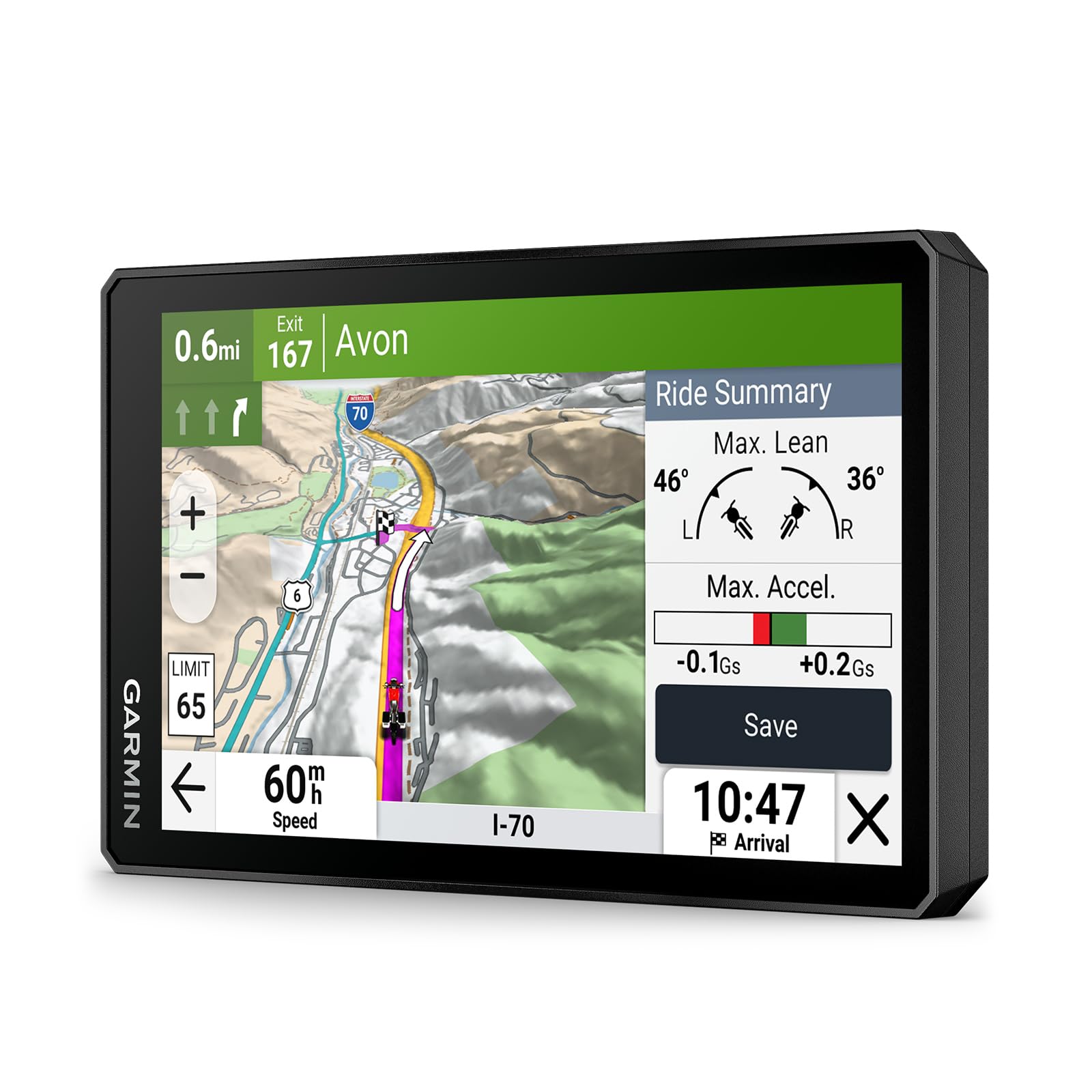
The zūmo XT3 brings a 6-inch high-definition display to the handlebar, making it easy to read trail numbers and split-screen navigation at a glance. The IP67 rating ensures it survives handlebar vibration, rain, and mud without skipping a beat. The ultrabright, sunlight-readable panel stays visible even when you are riding straight into the afternoon sun.
Preloaded street and high-definition topographic maps give you flexibility whether you are on a paved road to the trailhead or deep in the woods. The live lean angle gauge shows how far you have leaned into each turn, and the Tread smartphone app logs G-force, max speed, acceleration, and deceleration after every ride. Group ride functionality lets you see other riders on the same route, which is handy for keeping a convoy together.
The visual route planner on the device itself is intuitive, and the Adventurous Routing setting prioritizes curvy, scenic roads over straight-line efficiency. For riders who also hit the track, the optional Garmin Performance Package adds drag racing timer and lap time review. It is the most feature-dense GPS in this list.
Why it’s great
- Large 6-inch display with excellent daylight visibility
- Built-in lean angle gauge and ride analytics
- Group ride tracking via Tread app
Good to know
- Learning curve is steep due to dense feature set
- Not a significant upgrade for existing zūmo XT2 owners
3. Garmin Montana 710
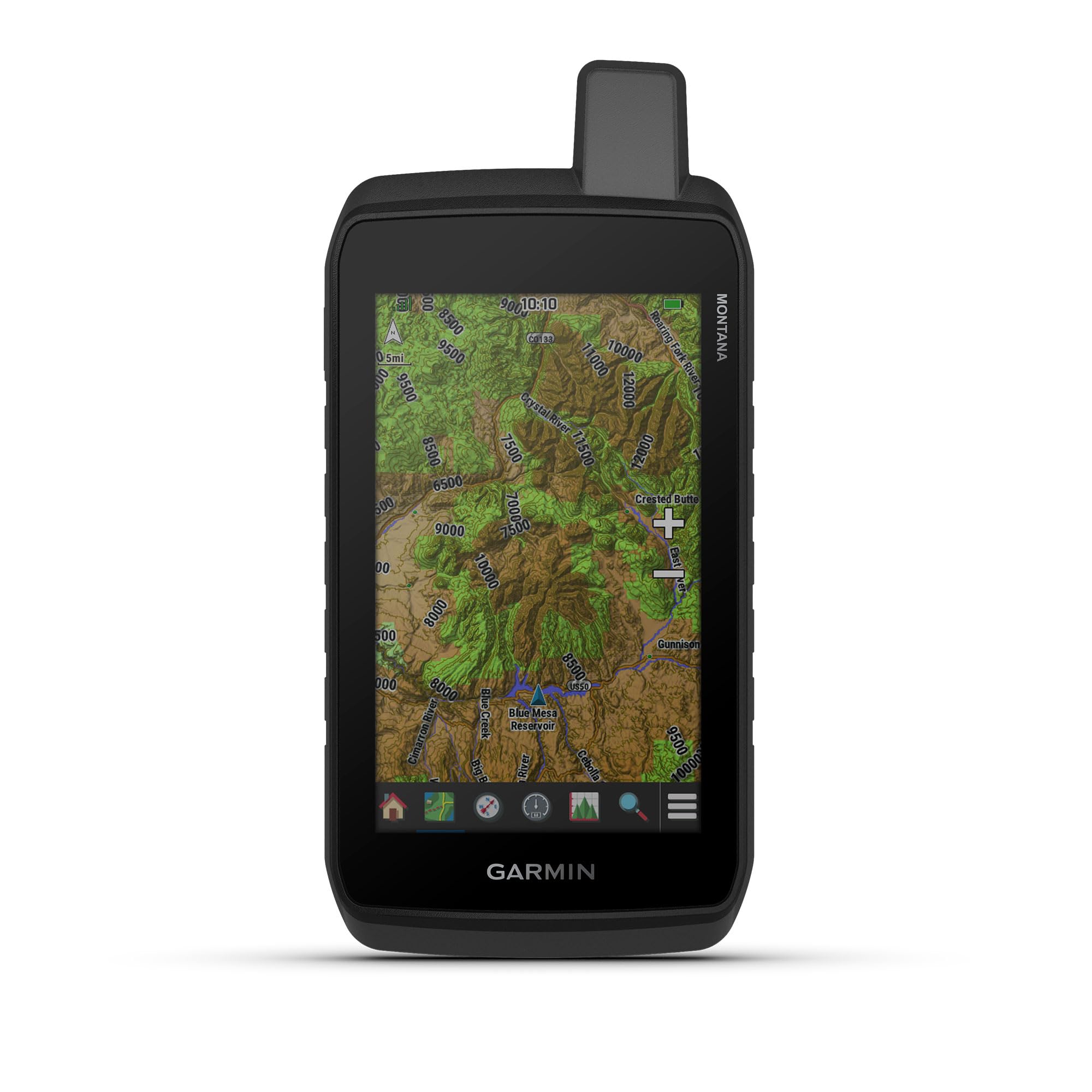
The Montana 710 bridges handheld portability with vehicle-mount utility. Its 5-inch glove-friendly touchscreen is large enough to see from the handlebar yet compact enough to pocket when you step off the ATV to scout a ridge. The MIL-STD 810 rating covers thermal, shock, and vibration resistance, so it survives drops and constant trail jolts.
TopoActive maps come preloaded, and you can add City Navigator street maps or BlueChart g3 marine charts separately. The 32 GB internal memory holds detailed 24K topo maps for large regions without needing an SD card. Battery life reaches 24 hours in GPS mode and jumps to 432 hours in expedition mode, which polls the satellites less frequently to conserve power.
USB-C charging is a welcome upgrade over older Garmin handhelds, and the ability to run on AA batteries gives you a fallback option on multi-day expeditions. ABC sensors (altimeter, barometer, compass) are built in, and you can access live weather via the Garmin Connect app on your paired smartphone. It is the most versatile GPS in the lineup.
Why it’s great
- Dual power source: rechargeable pack or AA batteries
- Large 5-inch display with excellent sunlight readability
- Supports TopoActive, City Navigator, and BlueChart maps
Good to know
- Some units have reported boot-loop issues
- Deleting pre-installed maps requires Basecamp software
4. Garmin Foretrex 801

The Foretrex 801 is a wrist-mounted GPS that prioritizes endurance above all else. On two AAA batteries, it delivers up to 100 hours of continuous GPS tracking — enough for a full week of backcountry riding without a recharge. The monochromatic display is always readable, whether under direct sun or through night vision goggles, and it consumes much less power than a color touchscreen.
Multi-band GNSS reception is a significant upgrade from the previous Foretrex 701, giving you reliable position locks even in steep canyons or under heavy canopy. Stealth mode stops storing and sharing GPS data, which is useful for military or tactical riders. The kill switch wipes device memory instantly if the unit is lost or compromised.
The Garmin Explore app lets you plan routes on your phone and sync them to the Foretrex. It also pairs with compatible inReach satellite communicators for two-way messaging. Jumpmaster mode calculates high-altitude release points for paragliding or parachuting, though most ATV riders will never use it. For pure navigation with zero battery anxiety, this is the unit.
Why it’s great
- 100-hour battery life on two AAA batteries
- Multi-band GNSS provides accurate locks in tough terrain
- Lightweight wrist-mount design keeps hands free
Good to know
- No maps — only breadcrumb trails and coordinates
- Button-only interface has a steep learning curve
5. Rand McNally RANDTAB7
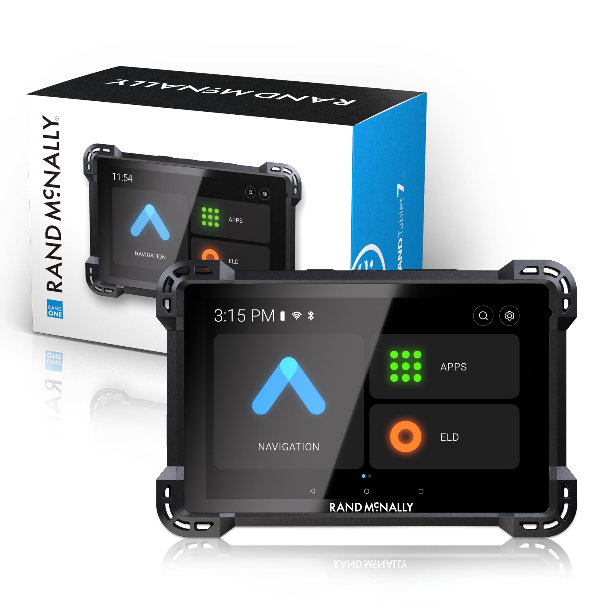
If you haul ATVs on a truck or trailer, the RANDTAB7 is designed for the towing reality. Its Rand Navigation 2.0 software with 2025-edition maps takes your vehicle’s specific dimensions — weight, height, width, and HazMat type — and routes accordingly. That means no surprise low-clearance bridges or weight-restricted roads when you are pulling a trailer.
The 8-inch stay-cool touchscreen is large and bright enough to read from the driver seat. Live traffic, weather, fuel price alerts, and speed camera warnings are built in. The powered magnetic mount holds the tablet firmly on rough pavement, and the barrel connector plus USB-C gives you redundant power options.
Points of interest include weigh stations, truck services, parking, and construction zones. The unit also has a built-in camera for image capture of incidents or landmarks. That said, some users report that the route recalculation is rigid — it sticks to its chosen path and rarely offers alternatives — and a few have experienced GPS signal dropouts on major highways.
Why it’s great
- Custom truck routing respects your load dimensions
- Large 8-inch display is easy to read while driving
- Includes live traffic, weather, and fuel price data
Good to know
- Route recalculation is inflexible — one path only
- Some users experience GPS signal dropout on US highways
6. Bushnell BackTrack Mini

The BackTrack Mini is a compact, waterproof GPS that focuses on one thing: getting you back to where you started. It captures your trip origin and displays a directional arrow pointing toward it, along with distance and elevation change. That simplicity makes it a good emergency backup, but it lacks the trail maps and waypoint management that serious ATV explorers need.
Battery life reaches up to 35 hours, and it charges via micro-USB, which is dated but functional. Bluetooth syncs with the Bushnell Connect app so you can view and share your trips on a smartphone. The large, glove-friendly buttons are easy to press even with thick winter gloves.
The main drawbacks are the lack of true mapping — you get coordinates and a compass bearing, not a visual trail network — and the finicky micro-USB port. Several users report that the app fails to sync after the device gets wet, and the distance readings can overestimate actual mileage by up to 60 percent. For the price, it is a basic safety net, not a primary navigator.
Why it’s great
- Simple one-button backtrack to trailhead
- Compact size fits in a pocket or glovebox
- Long battery life for multi-day trips
Good to know
- No built-in maps — only coordinates and compass
- Micro-USB port is unreliable and prone to failure
7. NiesahYan 3.2″ Topo GPS

This handheld GPS stands out in the budget segment because it actually includes USA topo maps. Most units at this price point only offer coordinate tracking, but the NiesahYan 3.2-inch model comes preloaded with topographical data and 32 GB of internal memory for additional map downloads. The sunlight-readable 3.2-inch screen and physical button controls work well in muddy or wet conditions where touchscreens would fail.
Multi-GNSS support covers GPS, Galileo, BeiDou, and QZSS, giving it a lock speed comparable to units costing three times as much. Position accuracy is rated within 6 feet. The 36-hour battery life on a single USB-C charge is competitive with mid-range Garmin units, and the IP66 water resistance handles heavy rain and creek splashes.
The 3-axis compass and barometric altimeter provide heading and elevation data even when stationary. However, some users have reported a critical failure where the device enters an infinite boot loop after the first field test, and the interface has been described as unintuitive for naming waypoints. It is a strong value proposition if you get a working unit, but the quality control inconsistency is a real concern.
Why it’s great
- Preloaded USA topo maps at a budget-friendly price
- 36-hour battery life with USB-C charging
- Multi-GNSS support for fast satellite locks
Good to know
- Some units experience boot-loop failures
- Waypoint naming and interface are not intuitive
8. APHQUA 722 CarPlay

The APHQUA 722 is not a traditional GPS with preloaded maps — it mirrors Apple CarPlay or Android Auto from your smartphone onto a 7-inch waterproof touchscreen. That means you get Google Maps, Gaia GPS, or whatever app you already use, projected onto a handlebar-mounted display. The 1600×600 resolution panel is sharp and features auto-brightness that adjusts for direct sun or night riding.
IP67 waterproofing means it can survive submersion in up to one meter of water for 30 minutes, which is overkill for most ATV rides but reassuring for extreme conditions. Dual Bluetooth lets you connect both your phone and a helmet headset simultaneously, so turn-by-turn directions stream directly into your helmet. Voice control via Siri or Google Assistant works well for hands-free navigation changes.
The touchscreen is slow — several users note a noticeable lag between tap and response — and the interface occasionally stutters. Boot time is around 9–10 seconds, which is acceptable. It works with riding gloves and even survives pressure washing, but the lack of built-in maps means you are entirely dependent on your phone’s signal and data connection for off-road routing.
Why it’s great
- Large 7-inch display with excellent sunlight visibility
- IP67 waterproof — survives submersion and pressure washing
- Wireless Apple CarPlay and Android Auto integration
Good to know
- Touchscreen response is noticeably slow
- Requires smartphone and data connection for navigation
9. NiesahYan A6

The NiesahYan A6 is the entry-level option for riders who want a dedicated GPS but cannot justify a premium investment. It supports four satellite constellations (GPS, Galileo, BeiDou, QZSS) for fast locks and reasonable accuracy, and its 2.4-inch sunlight-readable color screen is bright enough for daylight trail use. The 20-hour battery life covers a full day of riding with margin to spare, and USB-C charging is convenient.
The A6 records tracks and waypoints and can guide you back to your starting position via a backtrack feature. It includes a barometric altimeter and sunrise/sunset times. However, this unit has no built-in maps whatsoever — you navigate by coordinates and breadcrumb trails, which is frustrating on unfamiliar trail networks.
Customer feedback reveals a split between buyers who find it works well for simple backtracking on known trails and those who were disappointed by the lack of map visualization. The menu system takes time to learn, and some users report steep winding trails cause inaccurate position logging. For the price, it is a capable coordinate tracker but not a proper navigator for complex off-road riding.
Why it’s great
- Strong satellite lock from four GNSS constellations
- 20-hour battery life with USB-C charging
- Rugged waterproof build at a low entry price
Good to know
- No built-in maps — coordinate tracking only
- Menu interface requires patience to learn
FAQ
Can I use my smartphone instead of a dedicated ATV GPS?
What does multi-band GNSS mean for ATV navigation?
How long should the battery last for a full day of ATV riding?
Do I need preloaded topo maps or are breadcrumb trails enough?
Final Thoughts: The Verdict
For most riders, the best atv gps winner is the Garmin Tread because it bundles preloaded topo maps, a glove-friendly ultrabright touchscreen, and a powered mount that eliminates battery anxiety on long rides. If you want the longest battery life in a wrist-mount form factor, grab the Garmin Foretrex 801. And for riders who also tow ATVs on a trailer, nothing beats the Rand McNally RANDTAB7 with its load-specific truck routing.