An unreliable navigation signal or a blank screen in the middle of a cross-country flight is every pilot’s worst-case scenario. The difference between a routine leg and an emergency diversion often comes down to the quality of the navigation equipment mounted to your yoke or stowed in your flight bag. Whether you’re flying IFR in controlled airspace or navigating backcountry strips with only a handheld backup, the right GPS system provides the situational awareness, terrain warnings, and traffic data that keep you ahead of the aircraft.
I’m Min — the co-founder and writer behind Gadgets Feed. I’ve spent hundreds of hours dissecting the technical specifications, customer flight logs, and firmware update histories of portable and panel-mounted aviation GPS systems to separate the true workhorses from the overhyped gadgets.
No pilot should gamble on cheap electronics when lives and expensive avionics are on the line. My hands-on analysis of receiver sensitivity, battery endurance, map detail, and WAAS accuracy will help you find the best aviation gps systems for your specific flying mission.
How To Choose The Best Aviation GPS Systems
Selecting an aviation GPS goes far beyond simply picking the most expensive model with the biggest screen. You need to match the device’s capabilities—portable versus fixed-mount, battery type, map detail, ADS-B integration, and navigation receiver sensitivity—to the specific aircraft you fly and the kind of flying you do most often.
Navigating the Display and Mounting Trade-offs
Portable handheld units like the Yaesu FTA-850L or the Garmin aera 660 offer extreme flexibility: you can use them as a primary nav source in a rental aircraft or toss them in a flight bag as an emergency backup. The critical spec to check here is the display quality in direct sunlight. A transflective TFT or high-brightness LCD (like the aera 660’s 5-inch WVGA display) ensures you can read the moving map without craning your neck or squinting. Hard-mount panel units or yoke-mount cradles add stability but reduce portability—decide whether you need one GPS across multiple airplanes or a dedicated unit in your own cockpit.
Battery Life and Power Architecture
Battery longevity separates field-ready units from desk ornaments. Handheld aviation radios with built-in GPS, like the Icom IC-A25N, deliver around 10.5 hours on a single charge, while dedicated portable navigators such as the Garmin aera 660 average only 4 hours in GPS mode. The difference comes down to the device’s primary function: a radio’s power budget prioritizes transmission rather than a constant high-refresh map. For extended cross-country flights, look for units that accept external power via a yoke cable or have quick-swap battery packs. Also, consider lithium-ion versus alkaline trays—lithium performs better in cold cockpits at altitude.
Understanding ADS-B, WAAS, and Position Source
WAAS (Wide Area Augmentation System) is not optional for serious IFR work—it provides lateral and vertical guidance with accuracy under 3 meters. Products like the Stratux ADS-B receiver and the Garmin aera 660 fully leverage WAAS and multi-constellation GNSS (GPS + GLONASS + Galileo) to deliver stable position data even in turbulent, high-latitude environments. ADS-B In capability adds a layer of safety: the Stratux unit, for instance, streams subscription-free traffic and graphical weather (NEXRAD, METARs, TAFs) directly to an iPad running ForeFlight or WingX. If you fly in busy airspace or frequently encounter convective weather, ADS-B In integration should be near the top of your requirement list.
Quick Comparison
On smaller screens, swipe sideways to see the full table.
| Model | Category | Best For | Key Spec | Amazon |
|---|---|---|---|---|
| Garmin aera 660 | Portable Navigator | Touchscreen primary nav backup | 5-in WVGA, WAAS + GLONASS | Amazon |
| Icom IC-A25N | Handheld NAV/COM | Long-duration backup comms | 10.5-hr battery, 6W PEP TX | Amazon |
| Yaesu FTA-850L | Handheld NAV/COM | Color display with Bluetooth headset pairing | 66-ch WAAS GPS, color LCD | Amazon |
| Stratux ADS-B Dual Band | ADS-B Receiver | Subscription-free traffic & weather | 978/1090 MHz, WAAS GPS, AHRS | Amazon |
| Furuno GP39 | Fixed-Mount Marine GPS | Ruggedized standalone navigation | 4.2-in color LCD, NMEA legacy | Amazon |
| Yaesu FTA750L | Handheld NAV/COM | Ruggedized backup radio with GPS | Li-Ion battery, VOR/ILS receive | Amazon |
| Simrad GS25 | GPS Antenna / Heading Sensor | NMEA 2000 heading for radar overlay | 32-ch, magnetic heading, waterproof | Amazon |
| Garmin GPSMAP 64sx | Handheld Outdoor GPS | Hiking & off-trail navigation backup | 16-hr batt, quad-helix antenna | Amazon |
| Standard Horizon GX2410GPS | Fixed-Mount Marine VHF | Integrated AIS receiver & GPS | Internal GPS, AIS, NMEA2000 | Amazon |
| Garmin inReach Explorer+ | Satellite Communicator | Off-grid SOS & two-way texting | Iridium SOS, preloaded TOPO | Amazon |
| Autel EVO II Pro RTK V3 | Survey-Grade UAV | Centimeter-level mapping & photogrammetry | RTK + PPK, 1-in CMOS, 6K HDR | Amazon |
In‑Depth Reviews
1. Garmin aera 660 Touchscreen Aviation GPS Portable

The Garmin aera 660 is the gold standard for portable aviation navigation, leveraging both GPS and GLONASS constellations for rock-solid position acquisition even in challenging northern latitudes. Its 5-inch capacitive touchscreen is visibly brighter than competing handhelds, making it readable under direct sunlight pouring through a cockpit window—a critical advantage when you’re flying VFR without a dedicated panel mount.
The device comes preloaded with detailed aviation basemaps, and the built-in Wi-Fi allows database updates (SafeTaxi, obstacles, terrain, and NavData) directly from your home network, bypassing the need for a computer. The intuitive menu layout mirrors the Garmin GTN 625, so transitioning to a panel-mount navigation system feels seamless. The lithium-ion battery delivers around 4 hours of continuous GPS running time, which is sufficient for most single-leg flights, and the yoke-mount cradle keeps it secure on rough approaches.
Adding ADS-B weather and traffic requires pairing with a Garmin GDL 50 or 345 transponder, but as a standalone IFR/VFR backup, the aera 660’s terrain awareness and approach chart overlays make it the most capable portable GPS in this roundup. The yearly database subscription runs about for US NavData, obstacles, and terrain, which is a reasonable investment given the safety it unlocks.
Why it’s great
- Excellent sunlight-readable 5-inch WVGA touchscreen
- Dual-constellation GNSS (GPS + GLONASS) for fast, reliable lock
- Intuitive UI similar to Garmin panel-mount navigators
Good to know
- Battery life limited to 4 hours in GPS mode
- Database subscription is an additional annual cost
- No built-in ADS-B receiver without external module
2. Icom IC-A25N 76 USA Aviation VHF Transceiver with GPS

Icom’s IC-A25N is the handheld transceiver that serious pilots reach for when a backup radio needs to double as a navigation source. The built-in 2350 mAh Li-Ion pack keeps you on station for up to 10.5 hours, easily covering a cross-country day with reserves for pattern work.
The 2.3-inch LCD features a dedicated night-mode with red backlighting that preserves your night vision without washing out the frequency digits. The flip-flop channel recall stores the last 10 NAV and COM channels, allowing you to quickly toggle between the ATIS frequency and clearance delivery without scrolling through memory banks. Built-in Bluetooth pairs with wireless aviation headsets like the Bose A20, cutting the cable clutter found with legacy Icom and Yaesu units.
The GPS receiver provides basic position data and supports direct-to navigation with distance and bearing to your selected waypoint. While it is not a replacement for a full moving-map navigator, the IC-A25N serves as a highly capable emergency nav tool when your primary avionics go dark. The USB-C charging and PC programming software streamline setup, though the button layout is dense and requires a few flights to memorize in turbulence.
Why it’s great
- Full 6W PEP output for extended transmission range
- Excellent 10.5-hour battery life on a single charge
- Built-in Bluetooth for wireless headset pairing
Good to know
- No moving-map GPS display, only waypoint bearing/distance
- Dense button layout can be difficult to operate with gloves
- Front-end filtering is weaker than some Yaesu competitors
3. Yaesu FTA-850L Color Bluetooth NAV/COM Aviation Transceiver

The Yaesu FTA-850L is arguably the most feature-dense handheld in the NAV/COM category, packing a 66-channel WAAS GPS receiver, VOR/LOC/ILS navigation, and a vibrant color LCD into a compact body that weighs under a pound. The WAAS GPS locks quickly and holds position stability (within one dot deviation on ILS approaches) even during moderate turbulence, making it a legitimate emergency IFR reference. The Bluetooth pairing with aviation headsets is seamless—the radio remembers previously connected devices and reconnects automatically on power-up.
The color display is a standout feature for situational awareness, showing airspace boundaries, frequencies, and waypoints in sharp contrast. However, the screen washes out significantly in bright, direct sunlight—a known weakness that Yaesu owners should plan for by adjusting brightness or using a shaded mount. The radio supports 8.33 kHz narrowband spacing, ensuring compatibility with European airspace requirements if you fly internationally.
The 2200 mAh Li-Ion battery delivers solid endurance for a full day of flying, and the included alkaline battery tray provides a backup when you cannot recharge. The VOR and ILS receiver guidance adds an extra safety layer, although the radio cannot transmit on ILS frequencies simultaneously with COM due to its single-channel architecture. The PC programming software is functional but manual data entry remains the fastest route for most pilots.
Why it’s great
- Integrated 66-channel WAAS GPS with VOR/ILS nav support
- Bluetooth pairs automatically with wireless headsets
- Compact size with alkaline battery backup tray
Good to know
- Color display difficult to read in direct sunlight
- Single-channel design prevents simultaneous ILS and COM
- Not a legal ILS replacement for primary IFR navigation
4. Stratux ADS-B Dual Band Receiver Aviation Weather and Traffic

The Stratux ADS-B Dual Band receiver is the most cost-effective way to bring subscription-free traffic and weather into your iPad-based EFB. It listens on both 978 MHz (FIS-B weather, air-to-air traffic) and 1090 MHz (air-to-ground transponder pings), giving you the full ADS-B picture without the monthly fee of a Garmin GDL or Stratus subscription. The internal GPYes WAAS GPS receiver provides position data that feeds ForeFlight, WingX, or any GPS-enabled EFB app, and the AHRS module adds artificial horizon backup for partial panel scenarios.
The unit runs on a Raspberry Pi 3 platform, and the latest firmware (v1.6r1) is preloaded on the included MicroSD card, so setup takes about five minutes—mount the suction cup, connect the 10000 mAh battery pack, and join the Stratux Wi-Fi network from your device. The included high-gain dmurray14 antennas are tuned for aviation frequencies and provide reliable reception above 1,500 feet AGL, with weather data updating automatically throughout the flight. The 4+ hour battery runtime covers most local flights, and a larger external battery can extend that to a full cross-country day.
One thing to note is the “home-built” look of the unit—the protruding antennas and exposed circuit board will not win any cockpit beauty contests, but the raw functionality is hard to beat at this price point. The micro USB connector on the Pi is delicate and can loosen over time, so handle the cable connection carefully. The internal fan can also become noisy after extended use, though a small stick-on vibration pad solves the issue.
Why it’s great
- Subscription-free ADS-B traffic and weather for tablet EFBs
- Integrated WAAS GPS and AHRS for partial panel backup
- Simple plug-and-play setup with preloaded firmware
Good to know
- Exposed antennas and circuit board look DIY
- Micro USB connector is fragile and may loosen over time
- Internal fan can become noisy with extended use
5. Yaesu FTA750L Handheld VHF Transceiver / GPS

The Yaesu FTA750L is the predecessor to the FTA-850L but remains a strong contender for pilots who prioritize rugged construction and proven reliability. Its solid die-cast frame and weather-sealed chassis have survived countless drops on hangar floors and splashes from open cockpit doors. The VOR and ILS receiver modules provide basic instrument approach guidance, and the built-in GPS logs waypoints and flight tracks for post-flight review.
The 66-channel airband receiver is sensitive and delivers clear reception even at low altitudes near the airport boundary. The NOAA weather band monitoring is a nice touch for preflight briefs. The PC programming software (YCE01) works on Windows but the interface is dated, and many pilots find manual frequency entry faster for the small channel count they regularly use. The battery system includes both a Li-Ion pack and an included alkaline tray, so you can keep flying even if you forget to charge.
One shared weakness with the FTA-850L is the VOR/ILS setup complexity—configuring it for an approach in flight is not intuitive and requires preflight preparation. The AM squelch works well for most tower and approach frequencies, but some users report that the lowest volume setting is still too loud for quiet cockpit environments. The small button size can be tricky with gloves, though the overall ergonomics are solid for a handheld.
Why it’s great
- Extremely rugged, weather-resistant construction
- Dual battery system (Li-Ion plus alkaline tray)
- Sensitive receiver with VOR/ILS backup navigation
Good to know
- VOR/ILS setup is too complex for quick in-flight use
- Lowest volume setting still loud in a quiet cockpit
- PC software interface is dated and unintuitive
6. Furuno GP39 GPS, 4.2 Color LCD, Receiver with Antenna
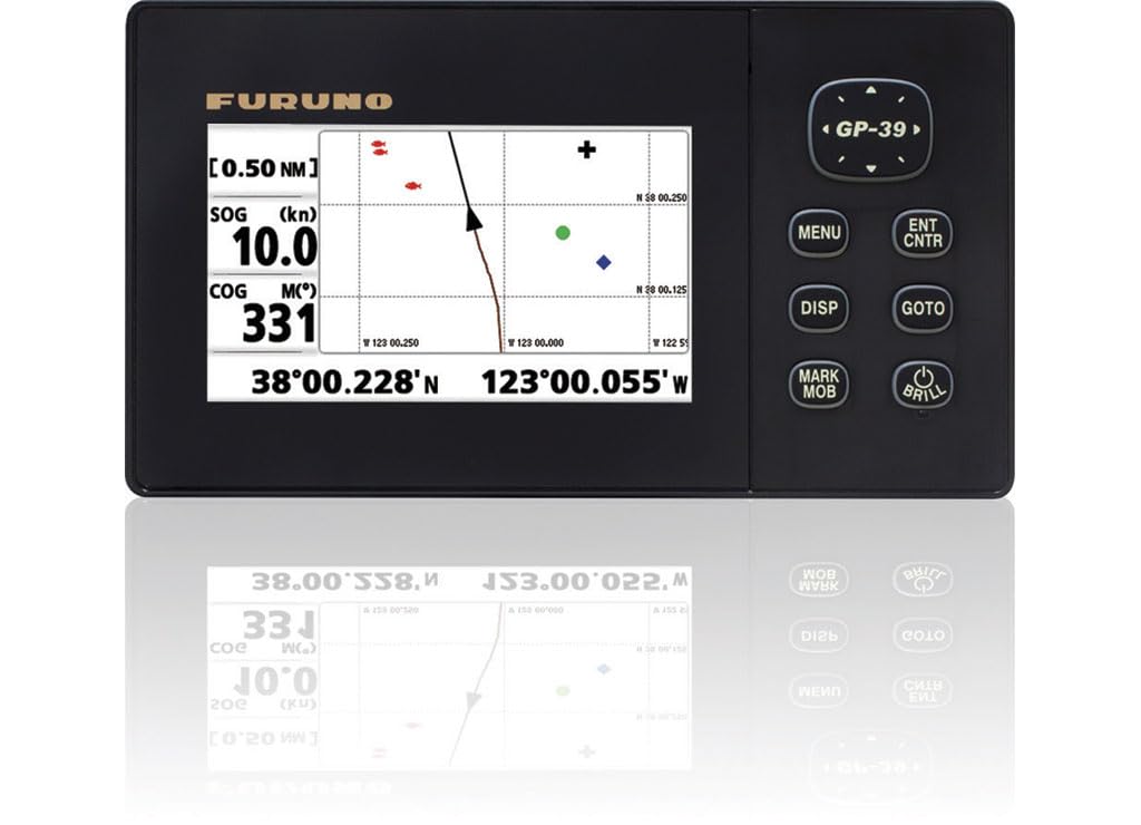
The Furuno GP39 is a fixed-mount marine GPS that aviation enthusiasts and float-plane operators turn to for its legendary reliability and simple button-driven interface. It eschews the glossy touchscreens of modern consumer units in favor of a 4.2-inch color LCD and physical buttons that you can operate by feel in turbulence or with heavy gloves. The unit stores up to 10,000 waypoints, 100 routes, and 3,000 points of ship track, offering deep memory for backcountry exploration.
The NMEA 0183 and selectable legacy NMEA version support make the GP39 compatible with older autopilots, nav receivers, and AIS transponders that would reject modern NMEA 2000 data. The included antenna puck mounts easily on a glare shield or external bracket, providing fast acquisition with its 32-channel receiver. The power draw is around 0.35A, double that of older Furuno units, but still within the capacity of most aircraft electrical systems.
The main limitation is the lack of built-in Wi-Fi or NMEA 2000 connectivity, meaning you cannot feed GPS data wirelessly to a tablet or integrate it directly with modern MFDs without an adapter. The mounting system angles the display down on vertical surfaces, which can make viewing difficult in some aircraft profiles. The manual is thin on I/O setup details, requiring some trial and error to configure NMEA output for external devices like an AIS receiver.
Why it’s great
- Rock-solid reliability with simple button operation
- Supports legacy NMEA protocols for older avionics
- Large waypoint and route memory capacity
Good to know
- No Wi-Fi or NMEA 2000 built-in
- Mounting bracket angles display on vertical surfaces
- NMEA output configuration is poorly documented
7. Simrad GS25 Waterproof GPS Antenna with Heading Sensor

The Simrad GS25 is not an aviation GPS in the traditional sense—it is a marine-grade GPS antenna with a built-in magnetic heading sensor—but it earns a spot here because amphibious aircraft operators and helicopter pilots flying over water rely on it for accurate heading and position data for radar overlay and chart stabilization. The magnetic heading sensor outputs true bow direction even at zero speed, eliminating the “jumpy chart” problem that plagues GPS-only systems when you are hovering or taxiing slowly.
The antenna connects directly to any Simrad NS Series multifunction display or any NMEA 2000 network, providing fast 32-channel GPS position updates and heading data that can be shared with autopilots, radar, and chart plotters. The unit is fully submersible IPX-rated and can be pole-mounted or flush-mounted on any vessel, with a cable length of 4.5 meters that fits most console configurations. At 0.3 pounds, it is incredibly lightweight and easy to install with a standard through-hull or bracket mount.
One critical limitation: the GS25 is not suitable for MARPA radar tracking or autopilot steering, as it lacks the high-precision gyrocompass that those functions require. For users who need MARPA support, Simrad recommends the Precision-9 compass or a dedicated GPS compass. The heading sensor accuracy is sufficient for radar overlay and basic autopilot heading hold, but it will not maintain a straight line in heavy crosswinds or currents.
Why it’s great
- Provides magnetic heading even at zero speed
- Fully waterproof with easy pole or surface mounting
- Connects to Simrad NMEA 2000 networks and plotters
Good to know
- Not suitable for MARPA radar or autopilot steering
- Heading accuracy less than a dedicated gyrocompass
- Primarily designed for marine, not aviation panel integration
8. Garmin GPSMAP 64sx Handheld GPS with Altimeter and Compass

The Garmin GPSMAP 64sx is a rugged, water-resistant handheld GPS that serves as a reliable terrain navigation tool for pilots who hike into backcountry airstrips or need a solid backup for off-airport flights. Its quad-helix antenna and multi-constellation support (GPS, GLONASS, and Galileo) provide fast position locks under heavy tree canopy or in steep canyon walls where patch antennas fail. The 2.6-inch sunlight-readable color display is easy to read from the flight deck, and the button-only interface works perfectly with flight gloves.
The preloaded TopoActive maps (US and Australia) include routable roads and trails, making it an excellent companion for flying into remote dirt strips where satellite imagery is outdated. The 3-axis compass with barometric altimeter delivers accurate heading and altitude data even when you are stationary or turning slowly on the ground. Battery life reaches up to 16 hours in GPS mode, which covers multiple days of expeditionary flying without recharging.
One drawback is the limited internal memory—there is no included microSD card, so you will need to supply one if you want to load additional maps or aerial imagery. The BaseCamp software is useful for trip planning but has a learning curve, and the manual is dense. While the GPSMAP 64sx is not an aviation-specific navigator, its off-trail navigation strength and reliable sensor suite make it a practical backup for pilots who venture beyond paved runways.
Why it’s great
- Excellent satellite reception under tree cover with quad-helix antenna
- Long 16-hour battery life in standard GPS mode
- 3-axis compass and barometric altimeter for reliable position data
Good to know
- Limited internal memory; microSD card not included
- BaseCamp software has a steep learning curve
- Not an aviation-specific navigator; lacks aviation data
9. Standard Horizon GX2410GPS Fixed Mount VHF with AIS
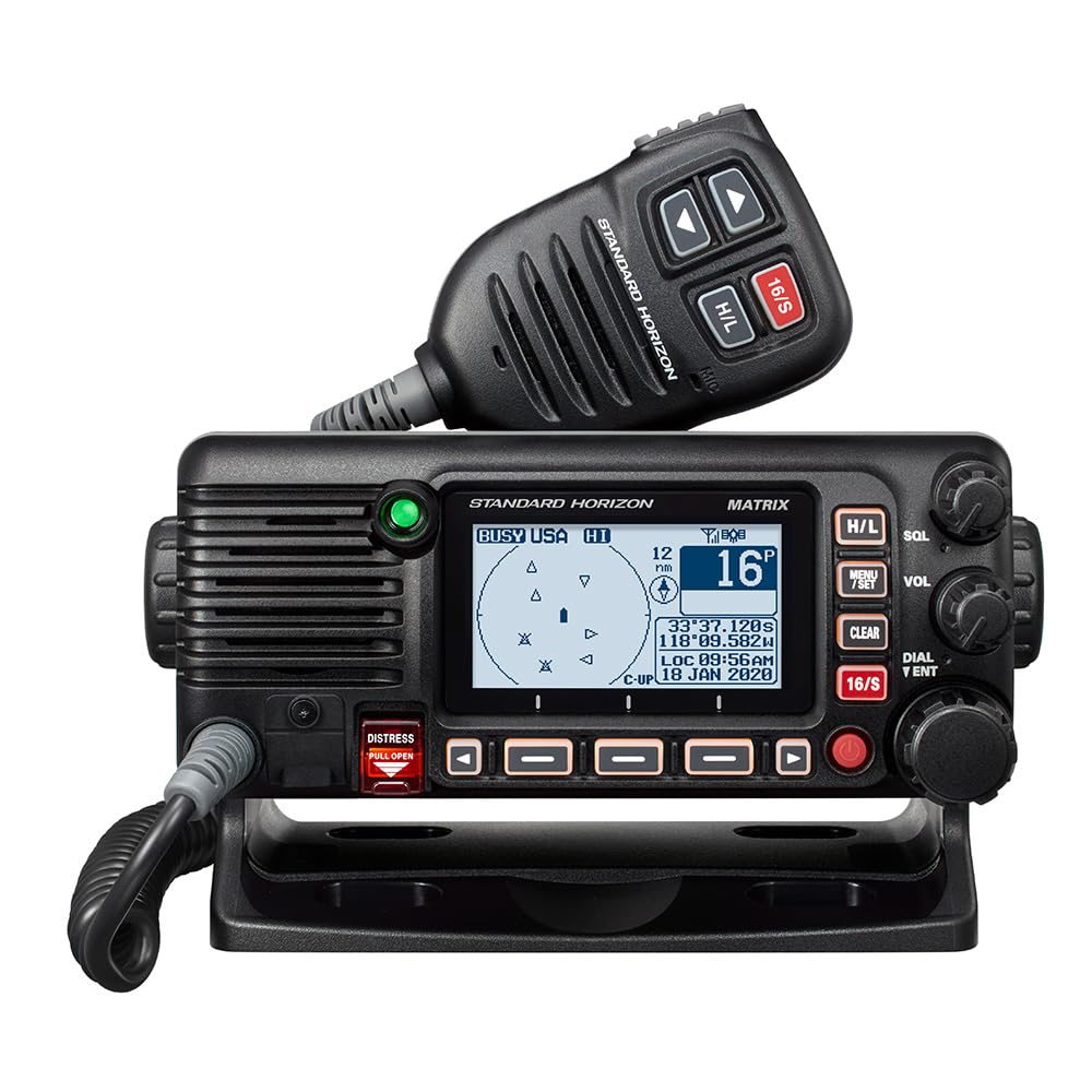
The Standard Horizon GX2410GPS is a fixed-mount marine VHF radio that brings internal GPS, AIS reception, and NMEA 2000 connectivity into one clean cockpit panel slot. It is an excellent choice for helicopter pilots or amphibious aircraft operators who operate in coastal or high-traffic maritime environments where ship traffic awareness is as critical as air traffic. The internal GPS provides position data to the DSC distress function, automatically sending your coordinates in an emergency.
The AIS receiver listens for vessel transponder signals and displays nearby ship positions, names, and MMSI numbers on the front panel LCD. It does not transmit your AIS position—that requires a separate AIS transceiver—but it provides enough situational awareness to avoid merchant traffic in busy approach paths. The NMEA 2000 interface allows the radio to share GPS data with other instruments on the network, reducing the need for a dedicated GPS antenna.
Bluetooth connectivity pairs with a smartphone or tablet for wireless DSC calling and radio setup, though the app is basic. The 25-watt transmit power delivers solid range for coastal communications, and the included dust cover and mounting bracket make installation straightforward. The primary drawback for aviation use is the lack of airband frequencies—this is strictly a marine radio and cannot be used for aircraft communications. It is best suited for specialized rotorcraft or amphibious operations.
Why it’s great
- Integrated AIS receiver for ship traffic awareness
- Internal GPS feeds DSC distress and NMEA 2000 network
- 25-watt transmit power with Bluetooth pairing
Good to know
- Marine-only VHF; no airband frequency support
- AIS is receive-only, does not transmit your position
- Bluetooth app functionality is basic
10. Garmin inReach Explorer+ Satellite Communicator

The Garmin inReach Explorer+ is not a GPS navigator in the traditional sense—it is a two-way satellite communicator with global Iridium coverage that doubles as a mapping GPS. For pilots flying over remote wilderness, open ocean, or developing nations where cellular coverage is absent, the inReach provides the only reliable link to emergency response. The dedicated SOS button connects you to the 24/7 Garmin Response coordination center, which dispatches local search and rescue anywhere on the planet.
Beyond the emergency function, the Explorer+ includes preloaded DeLorme TOPO maps with routable trails, waypoints, and location tracking that can be shared with family or ground support via the Earthmate app. The button-and-touchscreen hybrid interface works with gloves and in wet conditions, though the older DeLorme map data is noticeably outdated compared to Garmin’s current offerings. The new battery provides 4-5 days of intermittent use with tracking intervals set to 10 minutes.
The main downside is the subscription cost—the device itself is just the beginning, and the required Iridium plan adds a monthly fee that varies by usage tier. The microUSB charging port feels dated, and the unit requires a computer connection for firmware and map updates, which is inconvenient. It is a specialized tool for expeditionary flying, not a daily cockpit instrument, but its lifesaving potential is unmatched.
Why it’s great
- Worldwide Iridium satellite coverage for SOS and two-way texting
- Preloaded TOPO maps for remote terrain navigation
- Works with gloves and in wet conditions
Good to know
- Requires a monthly Iridium subscription plan
- Older DeLorme maps are outdated
- MicroUSB charging and computer-only updates are inconvenient
11. Autel EVO II Pro RTK V3 Drone
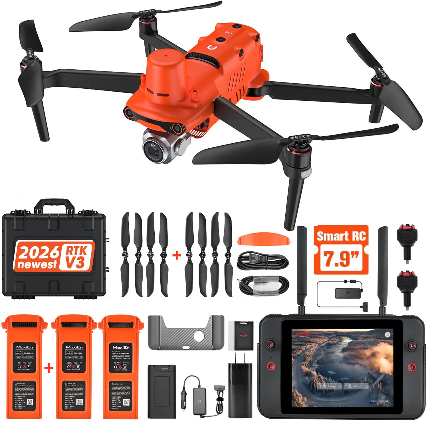
The Autel EVO II Pro RTK V3 is a survey-grade unmanned aircraft system designed for professional mapping, photogrammetry, and search-and-rescue operations. Its RTK module provides real-time centimeter-level positioning (1 cm + 1 ppm horizontal, 1.5 cm + 1 ppm vertical), eliminating the need for ground control points in many scenarios. The 1-inch Sony CMOS sensor captures 6K HDR video at 30 fps and 20-megapixel stills, delivering the geometric accuracy needed for orthoimagery, point clouds, and CAD-grade deliverables.
The flight autonomy features include waypoint tasks, rectangle and polygon mapping missions, and oblique photography profiles that can be programmed in advance and executed without manual stick input. The V3 supports both RTK base station and RTK network corrections, as well as PPK post-processing for environments where real-time differential data is unreliable. With a 38-minute maximum flight time and a 15-kilometer transmission range, the platform covers large-area surveys in a single sortie.
The RTK V3 bundle includes the aircraft, smart controller, three batteries, multi-charger, and a hard-shell case, making it a complete out-of-the-box solution. The main caveats are the steep learning curve for mission planning software (Autel Mapper requires a Windows PC with a dedicated NVIDIA GPU) and the occasional firmware stability issues that have been reported by early adopters. Autel customer support has been slow to respond in some cases, which is a concern for time-sensitive commercial operations.
Why it’s great
- Real-time RTK centimeter-level positioning without ground control points
- High-quality 1-inch CMOS sensor with 6K HDR video
- Comprehensive autonomy with waypoint, polygon, and oblique mission profiles
Good to know
- Steep learning curve for mission planning and mapping software
- Firmware stability issues reported by some users
- Customer support responsiveness is inconsistent
FAQ
Can a handheld aviation GPS legally replace my panel-mounted IFR GPS?
Do I need a subscription for ADS-B weather on a Stratux receiver?
Final Thoughts: The Verdict
For most pilots, the best aviation gps systems winner is the Garmin aera 660 because it balances a bright touchscreen, dual-constellation GNSS, and aviation-specific database support in a portable form factor that works across multiple aircraft. If you want seamless NAV/COM integration in a single handheld, grab the Yaesu FTA-850L with its color display and Bluetooth headset pairing. And for subscription-free ADS-B traffic and weather on a tablet, nothing beats the Stratux Dual Band receiver.